
Great Malaga Path (GR 249). Stage 23. El Burgo - Ronda
1. Initiation Stage:
Access Starting point: From Alozaina and the Valle del Guadalhorce A-366, also from Ronda, Serrato or Ardales, as mentioned above.
Starting point: The square with the monument to Pasos Largos, at the intersection of the A-366 with roads to Serrato (MA - 5400) and Ardales (MA-5401).
Enjoy the walk safely: During the short section of road, beware of the traffi c, above all to cross the bridge over the river. Upstream, when you need to ford the Río Turón, it is normally a dry riverbed.
However, this river course comes from the Sierra de las Nieves, and a storm can turn the ford into very dangerous one, although this happens rarely. The stage is hard because of its length, the steep slopes and the solitude of landscapes that it spans. As there are no water supply points, the advance planning of all the details of the trip is essential. The Lifa pass is a place with enough altitude where weather conditions can be extreme. It is not uncommon for it to snow here. The good news is that you walking along a track in good condition where there is no possibility of getting lost.
2. Completion of Stage:
Access to finish point: The end of route coincides with the intersection of the A-397 to the Costa del Sol, A-374 to Seville, the A-367 to Malaga and the A-366 to Alozaina.
Finish point: Ronda fairground, next to Pasarela de Libertad, in the north-eastern part of the town.
3. Alternatives:
Possible "escape routes": There is no possibility of leaving the path other than on the tracks of the beginning or the end of the stage route, following them or retracing your steps.
No return point: As soon as you reach the Cornicabral and you see Cortijo de Lifa which is inhabited, it is a better idea to keep going. In case of very bad weather it is not advisable to continue uphill as weather conditions in Puerto de Lifa can be even more dire.
Connections to other footpaths and trails:
PR-A 90, El Calvario Capellán Hill – Turón, overlap at start, PR-A 91, Los Jiménez – Garzón spring, GR-7 E-4, Links up at the start of the stage.
Hazards:
• Crossing the River Turón during floods
• The Lifa Pass, for its Height above SLe (1,160m).
The dams of the River El Burgo (Up to km 8.7)
The route departs from the roundabout in El Burgo, at the meeting point of three roads: the A-366 road to Ronda and Alozaina, the MA-5400 to Serrato and the MA-5401 to Ardales. Nearby is the monument to Juan José Mingolla Gallardo, the bandit known as Pasos Largos. Go south along the shaded road towards Yunquera for 250 metres, during which you pass over the El Burgo river. It becomes the River Turón from here on and you make a right turn, heading west along the country track to the pass of La Mujer (or Los Diques).
Not far on, you will see signs for a short circular route and then a turning to the left for the shared initial section of the Fuensanta and Puerto de la Mujer paths (GR 243). The route then continues to the south-west, as the riverside undergrowth on the right becomes more complex in terms of species and plant development. There are tall Poplars and numerous Ash trees, but the banks by the deeper pools are for White willows. The clean waters often make it easy to spot the freshwater fish.
After 1.2 kilometres, there is a spring on your right, and then at 2.7 km you come to a pink marly-limestone outcrop which gleams in the sunlight. From here, you can see El Dique dam and there is a path that leads down to the bathing area of Azud Largo, a short and much recommended diversion. The track continues as the valley narrows, with high, steep slopes either side with a few areas of exposed rock and their folded strata on display.
At the 4.5-kilometre point, high up over to the north, you can see the enormous rockface of the Forest Park Ranger’s Lookout and the road to Ronda. Below this, is the El Nacimiento dam in a meander of the river. You now enter the Sierra de las Nieves National Park. The Pine forest gets much thicker and you pass the small fountain of El Quejigo stream. Meanwhile, the only property on this section, the Cortijo de la Hierbabuena is dedicated to the rearing of goats and sheep (km 6.3). The track then steepens slightly until, very close to the Puerto de la Mujer and by a leafy Holm oak, you turn off onto a footpath (km 8.6) that descends steeply towards the river. The two streams, the Sabinal and the Higuera have their confluence here. Both of these flow from the Spanish fir forest (Pinsapar) and the ravine of Cańada de las Ánimas. In the wedge of land between the two are the ruins of the Cortijo de la Troncha, which the original trail passed by, and the boundary of the National Park.
The Turpentine woodland at Lifa (Up to km 11)
As you climb up parallel with the banks of the Lifa stream, keeping it on your left, the surrounding Aleppo pine forest is enriched with Holm oak, Kermes oak, Wild Olive, Mastic and Turpentine trees, with Rose bushes and other Mediterranean shrubs, most evident near the water’s edge. The path passes through an area reclaimed more recently by native vegetation. The original mounds of gathered rocks and cleared areas for dry arable crops are still visible, along with Olive and wild Olive trees. Although the path does not get near it, not far away are the ruins of the Cortijo de Buenavista, which was once the nerve centre of this farmland. Next to the boundary signs of the Sierra de las Nieves Natural Park, the Turpentine trees gradually become more abundant until they turn into woodland. The largest of these trees are on the first steep slope, at the foot of a limestone cliff (km 10.3).
You pass by the almost unnoticeable and rugged ravine of Cańada de Sopalmito on the right, which serves as a reminder of the bloody final part of the life of the local bandit, Pasos Largos. The path then continues halfway up the slopes of the Sierra Blanquilla. Clusters of slope debris look like limestone dividers, while the rockfaces displaying their strata are on the right and the Turpentine woodland of Lifa is on the left. This latter site is at its most spectacular in autumn, when it comes to life with tones of red. It also completely covers a hollow at its western end, by the rock on which the Lifa watchtower sits, severely run down over the years.
On the horizon to the south is the silhouette of the Sierra de las Nieves (the Rocks of Ronda, of Los Enamorados and some Pinsapar – Spanish fir forest). Up ahead, standing out on a commanding ridge is the tree which lends its name to the Puerto del Pinsapo pass. Further up is the limestone karst landscape, covered by the Maple trees of the Riscos del Lirio.
The country estate and the mountain pass at Lifa (hasta el km 16.8)
When you reach near the Lifa Tower, the terrain becomes slightly less rugged all of a sudden. The path runs through the surroundings of the Cortijo de Lifa country estate, which is found on an extensive & treeless plain formed of clays. It is also sheltered by the surrounding hills and even has a well or two. The path crosses farmland and fields used for grazing, while passing through gates that must be closed behind you in order to keep livestock in their correct place.
You pass some houses on your left (km 12.3), while the route follows the track going uphill in a south-westerly direction. The vegetation changes substantially here due not only to human activity but also to the Height above SLe. There is a grove of Common hawthorn with Scorpion broom and Mediterranean daphne with a few Montpelier maple trees. On the limestone cliffs to the south, some dark and solitary Spanish firs survive on the rugged slopes of the Carramolo del Queso. After a few bends, you reach a rise (km 14.3), which has excellent views looking back to the flatter and treeless area of the Cortijo de Lifa. The backdrop of the Sierra Blanquilla hills beyond and the Sierras Cabrilla and Alcaparaín completes the scenery.
When the two twinned Great Paths reach the Puerto de Lifa, albeit travelling in opposite directions, you are at 1,160 metres above sea level and there are several Cytisus shrubs. This is an important point, being the watershed between two drainage basins: draining to the west into the Guadiaro River and to the east, into the Guadalhorce. Until this point, the track has run along the boundary of the Protected Natural Area, but now the Sierra de las Nieves Natural Park is definitively on your left. When the Great Malaga Path reaches kilometre 14.9, you begin the descent. Just where the valley sides narrow between Puerto Frío to the south and Los Peńoncillos to the north, the path turns westwards once again. There is a limekiln at the foot of the path and just before passing some ruins and stockyards, is the best viewpoint of the flatter terrain up ahead. Ronda lies beyond this and the limestone peaks in the provinces of Malaga and Cadiz complete the backdrop.
The Aguaya Plains (To the end of the stage)
The most pronounced mountain to the south is Sierra Hidalga. Also visible are some dark and very tall trees in the distance, which are century-old Spanish firs, the remnants of the primordial forests. The Holm oak forest on the northern slopes of these mountains, stands out as a dense mass against the grey limestone, in which Silver fir trees thrive. Holm oaks are gradually spreading out over the whole valley, especially since they are favoured for hunting big game, in particular for deer. This explains the cattle grids at the entrance and exit of the estate. The ruins of the El Lirio and Peńón Verde country houses, facing you to the south, tell a very different story, however.
You go through a second gate with a cattle grid and approach the now flowing stream of Los Lanceros. The descent becomes gentler (km 18.8) as you come on to the level terrain of the Aguaya Plains, a vast area of fields with numerous farmhouses around their edges. The most important junction is where the tarmac road begins. This is where the inn of Venta Ramirón was located, at the crossroads of the Camino de Yunquera, which the route now follows; and the Cordel de los Pescadores (the Fishermen’s line). This latter road happens to overlap with the Puerta Verde de Marbella. If you were to follow this renovated livestock track to the right, you would reach the Pilar de Coca. Or similarly, to the left would take you to an aerodrome and the Guadalevín river, before continuing on to the Fuenfría and the coastline of the Costa del Sol.
The Path continues straight on and climbs up to a small hill known as the Bilbao pass (km 22), from where Ronda comes into view once again. After a downhill section with a couple of bends, you come to a bridge over the Toma stream. This shares its name with the nearby building material business. A short way on brings you to the open space of Ronda’s Fairground on the left. The route ends at the so-called Pasarela de la Libertad (Freedom Footbridge).
 GR 249. Stage 23. El Burgo - Ronda. From the emergence of Los Fraguarones, the Burgo River usually goes with water much of the year
 GR 249. Stage 23. El Burgo - Ronda. When the new shoots begin to develop, the cornicabras return to the red colors of autumn
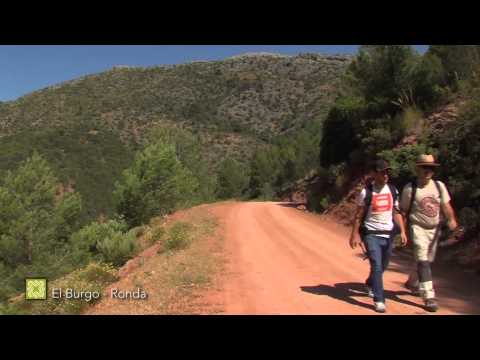
 GR 249. Stage 23. El Burgo - Ronda. A group of hikers heading to El Burgo during a rainy spring day in Lifa
 GR 249. Stage 23. El Burgo - Ronda. The last part of the route is ideal to see birds from the cereal steppes, as is a companion of wheat fields
 GR 249. Stage 23. El Burgo - Ronda. El Burgo - Ronda. The Mill Dam (Dique del Molino)
 GR 249. Stage 23. El Burgo - Ronda. The Peppermint Dam (Dique de la Hierbabuena)
 GR 249. Stage 23. El Burgo - Ronda. The new bridge of the Burgo
 GR 249. Stage 23. El Burgo - Ronda. Vegetation of the bank of the Turón River
 GR 249. Stage 23. El Burgo - Ronda. El Burgo River Dam
 GR 249. Stage 23. El Burgo - Ronda. Initial section of the road
 GR 249. Stage 23. El Burgo - Ronda. Crossing the riverbed
 GR 249. Stage 23. El Burgo - Ronda. Terebinth trees (Pistacia terebinthus) of Lifa
 GR 249. Stage 23. El Burgo - Ronda. Andalusian Wall Lizard (Podarcis vaucheri) in the track
 GR 249. Stage 23. El Burgo - Ronda. View of the Terebinth trees (Pistacia terebinthus) and medieval watchtower
 GR 249. Stage 23. El Burgo - Ronda. Pinsapo in the reliefs next to the Lifa Valley
 GR 249. Stage 23. El Burgo - Ronda. Port of Lifa
 GR 249. Stage 23. El Burgo - Ronda. View of Ronda from los Peńoncillos
 GR 249. Stage 23. El Burgo - Ronda. Llanos de la Aguaya and Ronda in the background
 GR 249. Stage 23. El Burgo - Ronda. The first dam of Río del Burgo following the direction of the path
 GR 249. Stage 23. El Burgo - Ronda. A damselfly rescued from the water at one of the dams over Turón river
 GR 249. Stage 23. El Burgo - Ronda. One of few monuments erected to commemorate a bandit, this one dedicated to Pasos largos in El Burgo
 GR 249. Stage 23. El Burgo - Ronda. Lifa farm is surrounded by wide pastures and fields
 GR 249. Stage 23. El Burgo - Ronda. The Azud Largo is used by locals for water sports and a summer swim
 GR 249. Stage 23. El Burgo - Ronda. Terebinth tree (Pistacia terebinthus)
 GR 249. Etapa 23. El Burgo - Ronda


More information
Discover more about the province of Malaga
- Discover more about the province of Malaga