
Great Malaga Path (GR 249). Stage 11. Alfarnate - Villanueva del Rosario
1. Initiation Stage:
Access Starting point: From the A7, from Vélez Málaga direction Periana and on the MA-155 to arrive to Alfarnate. There is another access from Colmenar and the A-6100. From the Puerto de Alazores, coming from Loja, the connection to the MA-155 is on the A-341.
Starting point: Plaza del Puente de Alfarnate.
Enjoy the walk safely: It must not be underestimated what altitude can mean at this stage. To the average elevation you must add the maximum height and mountain pass character; weather conditions can be very typical of mountains. The path sometimes has a stony surface and you may be walking directly on limestone pavement. You must wear the right footwear for such conditions.
It must bring appropriate footwear. There are no watering points until Hondonero, and even so it is not treated for human consumption.
2. Completion of Stage:
Access to finish point: From Málaga, the A-92 M, exit 20 toward the A-7203. From Granada, the A-92 exit 177 to the MA-92 direction Málaga and exit 16 to the MA-231 towards Villanueva de el Rosario.
Finish point: Villanueva del Rosario, at the intersection of Calle Arroyo with the Camino de las Lomas.
3 . Alternatives:
Possible "escape routes": The best chance for escape before climbing the highest mountain pass is retracing your steps the abandoned campsite (vehicle access) then down to Villanueva del Trabuco, which is very close. From the pass downwards, go to the Mirador de Hondonero, where there is car access and use the forest track to access Villanueva de el Rosario.
No return point: La Fuente de Toma y Bebe or the Llano de la Cueva.
Connections to other footpaths and trails:
PR-A 267, Pico Vila & PR-A 266, Las Pilas – overlap at start, PR-A 353, Sierra de San Jorge, partially
overlap in the mid-section, PR-A 339, Pathway of the 101 Cańos (Spouts), possible link-up, PR-A 394,Sierra Gorda, partial link-up in the mid-section, PR-A 395, Fuentes de Hondonero, partially overlap in final section, and SL-A 268, Fuentes de Hondonero, partially overlap.
Hazards:
• A climb up to a considerable height
• Karstic terrain – difficult and uneven walking surface
• Road traffic circulating at the start and end of the route .
Towards the Mountain Pass of El Quejigal (Up to km 3.8)
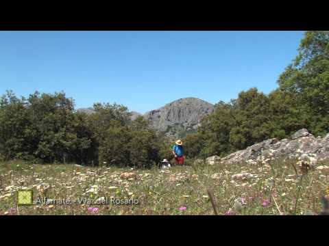
The initial part of the Stage is flat, crossing the fields of Alfarnate towards the mountains. The first notable landmark you come to is the crossing of the Arroyo Morales stream. It is a historic fording point, since it is part of the livestock track of the Vereda de Archidona (or del Fraile). You then cross the A-4152 road and the track gradually becomes more rugged with loose stones. Then you meet a steep slope which vehicles are prohibited from accessing. This was once a well-known footpath, the Escarigüela, which zigzags along on either side of the track. Holm oaks gradually become more frequent on the sunny flanks of the Sierra, however Scorpion broom dominates, with occasional Turpentine trees. The landscape is brought to life by the extraordinary karstic landscape at the Quejigal mountain pass, which even has seasonal pools.
The track improves considerably as it descends towards Villanueva del Trabuco through reforested areas with Aleppo pines. The town soon comes into view up ahead after passing the entrance to a farm on your left.
The hollows and depressions of El Quejigal (Up to km 6.8)
There is a sharp turn at km 4, next to a newly-built seasonal amphibian pond along a stream and the first of the buildings in the recreation area. At km 4.8 of the route, you reach the Villanueva del Trabuco Treetop Adventure Park, set in a large basin surrounded by large trees and with an enclosed lake.
Continuing on, you soon come to another basin, called the Virote hollow. It is surrounded by some fine examples of Aleppo pines, large Turpentine trees, very dense woodland of Holm oak and Portuguese oaks (Quejigos), which give their name to the whole area. You follow a footpath that goes up and along the bottom of the Vaga, a local expression for a valley, under dense Gall oak woodland. This brings you to a plain, where you begin to appreciate its elevation. A wire fence, which runs close to the boundary between the three municipalities, guides you to the left towards a small wire gate that leads to the threshing floor of Juan Moreno (km 6.8). This serves as proof of the agricultural practices in this peripheral and complex area for crop cultivation and farming.
Looking back from here are some spectacular panoramic views of the mountain ranges of the Central Limestone Arc, rounded off to the north by the rocky bulk of the Sierra de Loja.
Through the Sierra (Up to km 9.6)
The ravine which the Great Malaga Path now climbs up is in the Sierra del Jobo. The peak of the Morrón del Chamizo is to the east and the Sierra Gorda, to the west. It is difficult to appreciate the magnitude of this second limestone mountain from this position. It is though, from Villanueva del Trabuco, which backs on to it. The footpath then reaches the highest point on the entire GR, just where the Toma y Bebe fountain is found. Keep an eye out for the interesting sinkholes that characterise the area. Above you towards the left, there is also a well-used shelter with thick protective stone walls.
From the mountain pass of El Quejigo and the Llano de la Cueva plateau (km 8.3) at 1,385 m above sea level, you begin to drop down and the Dehesa de Hondonero gradually comes into view. Look for a footpath that takes you to the Hondonero viewpoint, passing by some impressive cliffs with some especially large Maple trees on the way.
The Dehesa de Hondonero traditional farmland (To the end of the stage)
At the Mirador (km 9.6), you take a wide track, which allows vehicle access all the way from Villanueva del Rosario, the stage’s destination. The viewpoint here has a privileged setting thanks to the amphitheatre-like rugged mountain ranges that surround it. The extensive views to the north across the flat expanses around the two Villanuevas, only add to this splendour. From this point on, you will see various information panels intended for those following the Great Malaga Path in the opposite direction. These display a broad range of information (in Spanish) about the Dehesa de Hondonero, and perhaps the most interesting is the information about its geology, its karstic lakes and springs.
The importance of the area lies, above all in the diversity of birds, orchids and geological formations. It is also very popular with walkers, cyclists and lovers of climbing and via ferratas.
The route continues to follow a largely westerly course, but it makes a sharp turn to the north just where the turn-off to the Tajo de la Madera is located. This impressive rocky outcrop of reddish rock is some 500 metres to the west.
The final section of the Stage takes you past successive springs between farmhouses, orchards and holiday homes. Olive trees begin to cover the landscape once again, especially over the wide-open plains visible from the pristine chapel of Nuestra Seńora del Rosario (km 14.3). A short detour is recommended from here, to visit the spring of El Chorro, which also feeds the Arroyo del Cerezo. The Great Path now continues between this latter stream’s emerging valley and that of another stream, the Arroyo de Canaleja. Heading towards the Canaleja, it soon reaches a little bridge that leads to the village of Villanueva del Rosario, bringing the Stage to a close.
 GR 249. Stage 11. Alfarnate - Villanueva del Rosario. Agrarian landscape in Los Llanos of Alfarnate
 GR 249. Stage 11. Alfarnate - Villanueva del Rosario. The Trail in the wildest area and at higher altitude
 GR 249. Stage 11. Alfarnate - Villanueva del Rosario. One of the lagoons of Hondonero with the mountain behind
 GR 249. Stage 11. Alfarnate - Villanueva del Rosario. Watering fountain near the Tajo de la Madera
 GR 249. Stage 11. Alfarnate - Villanueva del Rosario.
 GR 249. Stage 11. Alfarnate - Villanueva del Rosario. Entrance to the Sierra del Jobo
 GR 249. Stage 11. Alfarnate - Villanueva del Rosario. Era of Juan Moreno
 GR 249. Stage 11. Alfarnate - Villanueva del Rosario. Section from Sierra de Jobo to Hondoneros
 GR 249. Stage 11. Alfarnate - Villanueva del Rosario. Vegetation in the Sierra
 GR 249. Etapa 11. Alfarnate - Villanueva del Rosario. View of Camarolos from the Sierra del Jobo
 GR 249. Stage 11. Alfarnate - Villanueva del Rosario. Paeonia
 GR 249. Stage 11. Alfarnate - Villanueva del Rosario. Yellow bee-orchid (Ophrys lutea)
 GR 249. Stage 11. Alfarnate - Villanueva del Rosario. Rockslide at the foot of the Chamizo
 GR 249. Stage 11. Alfarnate - Villanueva del Rosario. Orchid (Orchis macula)
 GR 249. Stage 11. Alfarnate - Villanueva del Rosario. The Sierra of Jobo and the Pico Chamizo seen from Alfarnate plain
 GR 249. Stage 11. Alfarnate - Villanueva del Rosario. Plains of Alfarnate and Alfarnatejo soften the landscape that is viewed from the first stretches of the sierra
 GR 249. Stage 11. Alfarnate - Villanueva del Rosario
 GR 249. Stage 11. Alfarnate - Villanueva del Rosario. The Sierra de San Jorge and the Tajo Tello
 GR 249. Stage 11. Alfarnate - Villanueva del Rosario
 GR 249. Stage 11. Alfarnate - Villanueva del Rosario. Hermitage of the Virgen del Rosario, reaching the point of destination of the Stage in Villanueva del Rosario
 GR 249 Etapa 11 Cresterías calizas
 GR 249 Etapa 11 Laguna de Hondonero
 GR 249 Etapa 11 Roquero rojo
 GR 249 Etapa 11 Arce
 GR 249 Etapa 11 Mariposa endémica


More information
Discover more about the province of Malaga
- Discover more about the province of Malaga