
Great Malaga Path (GR 249). Stage 06. Frigiliana - Cómpeta
1. Initiation Stage:
Access Starting point: From the A-92 E-5 road take an exit direction Frigiliana onto the MA-5105.
Starting point: Plaza del Ingenio de Frigiliana.
Enjoy the walk safely: A climb of 1.350 metres of altitude should not be taken lightly. There are peaks of 1.700 m and higher in these mountains. The contour of the mountains is very rough, with semi-open valleys, gorges and ravines. This is why it´s
very dangerous to venture away from the signposted footpaths. Up to the halfway point of this stage there are places where you can stock up on untreated water or, at least, freshen up in summer. However, there is only one populated place along this stage. Also, the observation tower is possibly visited by workers during fi re risk season. The walk is long and tiring and it´s essential to plan well for such a physically demanding activity which will practically take up all of your day. Be careful walking the stretch of the road leaving Frigiliana up to the intersection of Cuatro Caminos. This part of the road is very narrow and lacks a hard shoulder.Not only should you walk on the left but also in a single file, making yourselves visible. Be extra careful at times of limited visibility.
2. Completion of Stage:
Access to finish point: There are two possibilities of exiting the A-92 E-5, direction Algarrobo or Torrox.
Finish point: Plaza del Carmen de Cómpeta.
3. Alternatives:
Possible "escape routes": This is truly complicated. Up to Cortijo del Daire (km 16) the best option is to go back (covering up to 8 kilometres) using the track towards El Acebuchal. From the point at El Collado de los Hornillos it would be advisable to try and reach the track of El Daire which passes underneath the footpath. The track from Cortijo del Daire has car access. You could continue along the GR and look for the forest track which takes you to the immediate surroundings of the observation point of Infoca and then come down towards Cómpeta or the Hotel de la Casa de la Mina.
No return point: Practically it would coincide with El Collado de los Hornillos, the highest point of Stage 6.
Hazards:
• Mountainous terrain and at reasonable Height above SLe
• Road traffic circulating up to km 6
• Two short sections on the MA-5105 road
Towards the village of El Acebuchal and Venta del Cebollero (Up to km 7.7)
It is possible to cross the white village of Frigiliana on Calle Real street, but the most direct exit is taking the MA-5105 road. It twists and turns, heading in the same direction, however soon enough it joins a section of the old Camino de Cómpeta road, passing by the fertile plains of the Arroyo de los Bancales. Occasional sections along here do benefit from road surfacing, given its proximity to the town and its intensive horticulture. You will spot avocados, pomegranates and cherimoyas occupying the age-old farmland on spectacular dry-stone wall terracing made with travertine rock. The views of Frigiliana during this first segment are excellent.
The first climb begins once you cross the ravine, passing between country houses until, all of a sudden you are free of the peri-urban area. The ascent is completed on a small footpath up the Loma de la Cruz (Ridge of the Cross), approaching the road at kilometre 2.3. Stay on the MA-5115 for 700 metres until you see a track on your right, heading up towards Cuatro Caminos. Entering the pine forests of the Natural Park, the winding track takes a north-eastern course and then begins its descent down to El Acebuchal. Look out for a house with a tiled mural telling a story of an orphaned girl who was buried and came back to life, including a rather ghastly tale of her remains being taken to Vélez-Málaga.
The history of the hamlets of El Acebuchal Alto and Bajo is closely linked to the Camino de Granada (Road to Granada), water and the 3 hectares of farmland on both the Frigiliana side and on the hillside of Cómpeta, around its dwellings. The story of how the village was repopulated after being abandoned is a captivating one and it serves to highlight the dedication of the rightful residents. It has converted itself into an example of rural tourism and gastronomy.
After 6.2 kilometres, a footpath leaves El Acebuchal going up a narrow & dry stream bed, occasionally making use of cutthroughs. Thanks to the shade provided by Aleppo and Maritime Pines, there is dense undergrowth with enormous Scorpion brooms and Rosemary shrubs as well as other plants that require plenty of water.
A kilometre past El Acebuchal is the compelling old Inn or Venta del Cebollero or del Jaro. Just beyond it are some beehives which take advantage of the dense cover of Rosemary bushes in this open area. Soon after this, you climb up steadily on the Camino de Granada, which incidentally is a non-stop incline until Venta Panaderos on the far side of the Sierra, in the Province of Granada. The Inn’s inhabitants used to supplement their livelihood in hospitality with 80 ‘obradas’ (32 hectares aprox.) of vineyards surrounding it in its day.
Apart from the nearby water source, it is the architectural elements of this and other surrounding buildings that most catch the eye and appear to be considerably older than the 18th century they have been dated as. They display fine examples of rammed-earth walls, compacted earth platforms with the holes for the scaffolding perfectly visible from the outside, all considered appropriate building techniques for this dry environment.
The network of country tracks (Up to km 14)
A network of forest trails, well used by mountain bikers begins shortly after the Venta. The Great Path proceeds uphill at kilometre 9.5 towards the Páez Blanco pass at 750 metres above sea level. To your left here, is the Cerro Verde, the site of bloody battles between the opposing sides in the Civil War, the reason for El Acebuchal’s forced abandonment. Much worthy of note are the Maritime Pine trees which have survived the same forest fires which ravaged the area earlier, as well as the albarradas, old stone wall terracing of the deserted vineyards.
The tracks in this area generally come up from El Acebuchal, navigating the rugged western slope of Cerro de las Tres Cruces and cover half the hillside around the Cortijo del Daire estate. Skirting the southern face of the Daire Ridge, they then pass around both sides of the Cerro Gavilán before descending its eastern and western faces towards Cómpeta. The GR-249 only utilizes these tracks from Cruz de Canillas up to the commented Cortijo.
In this track-filled section, you can admire the drop in elevation from El Cerro de las Tres Cruces down to the Moreno gorge. No less spectacular are the views of the mountain crest that rises up from the valley. Midway between the Cortijo and the mountain pass, stop off to see the engineering masterpiece of the dry-stone walls that secure the Dolomite sands. Tree Violets cling to the sides in between wispy Rosemary shrubs. The unexpected oasis of two streams, frequently with flowing water, awaits at the head of the valleys, where you cross them.
The Cortijo del Daire estate (km 14.1), deeply set in Andalusian nostalgia, dominates the wide valley from its privileged vantage point. There are some reasonably sized but difficult-to-spot caves on both sides of the estate, one of which is in Tavertine rock. Below the main house are stone wall terraces with thriving walnut, pomegranate, fig and wild olive trees just next to the beehives.
Towards El Collado de los Hornillos and La Cruz de Canillas (Up to km 20.5)
The upcoming section is the wildest on this Stage. Here, you abandon the forest trail at kilometre 14.4, and keep going along a footpath that climbs up white sandy slopes with dolomite crests. These are covered in Rosemary and Gorse, which have recovered from the fire that swept through these pastures not long ago. On the demanding way up, you pass paths going down to your left towards La Loma del Daire and to your right going up to a water catchment point and El Lucero summit. At the top of the rise, you come to the pass of Puerto de los Hornillos, where some fine examples of surviving Maritime Pines give us an idea of how the other side of the mountain would have looked originally. Puerto Blanquillo, a well-known spot and accessible by authorised off-road vehicles is just off to the north.
The mountain pass (km 16) is the highest point on the stage and where you change heading from north-westerly to southwesterly, descending the other Camino de Granada. You push on down a ravine that has pathways going off to the right, towards Puerto Blanquillo. A little further on is a crossroads in the path and a left would take you back to the Daire track, and eventually on to Casa de la Mina (Mine House). However, the traditional path continues straight on and just below it at this junction of paths, serving as proof of the route’s history is the Ventorro de Cándido.
The clearly marked footpath stays roughly at the same height until Venta de los Pradillos. Passing by the lime kilns and adjacent houses makes the coming and going of people & animals in its heyday seem not so long ago. One enormous Maritime Pine does stand out majestically in among younger forests and saplings, while to your left you pass the Arroyo de los Pradillos, the upper course of another important watercourse. At kilometre 20.5, you then make it to the Venta de María Guerrero, just short of a new track.
The view to the east from the ruins of the Venta are worth a special mention and almost the whole route from El Puerto de la Páez Blanca is on display, with the spectacular Barranco Moreno gorge in the middle and the Almijara summits as a backdrop. At the mountain pass of Cruz de la Canillas, you cross over to the other side of the ridge on the main track, bringing the magnificent Sierra Tejada into sight.
From La Cruz de Canillas to Cómpeta (To the end of the stage)
This new landscape is less intricate in its layout than the other side, but is at a higher Height above SLe. Sierra Tejada stands out to the north-west and the Sierra de Játar to the north. When you reach a white track, take the left-hand fork which progresses along the western flank of the watershed until the Collado Moyano pass heading firstly south, then south-west until the end. The track off to the west drops dramatically down to Canillas de Albaida, passing the old electricity plant, La Fábrica de la Luz. Just on a little, on your left you pass the vehicle access to the forest fire lookout post of Cerro del Gavilán.
The woodland of Maritime Pines you pass through now is of exceptional beauty. Its fine appearance owes itself to withstanding the thin and poor-quality soil, the harsh weather conditions in the region of battering wind and storms, grazing livestock and forest fires. In contrast to the replanted forests, each and every tree is unique in shape. Their twisting trunks, thick bark, crooked branches and stumpy appearance make them look more like enlarged Bonsai trees. At kilometre 21.9, you take the right fork, where the smaller left-hand track also drops down to Cómpeta meeting at the path intersection at Puerto del Collado.
Efforts to counteract the devastation caused by forest fires with the reforestation of Pines, have had varying degrees of success. Support stakes and sapling protectors, which are visible from the forest trail are evidence of this however, the latest large-scale forest fire has once again left a long-lasting mark on the area. Except for a short section of footpath which cuts the corner of a long curve in the track, the way down to Cómpeta’s water deposit and the football pitch is made on a gravel track. Look out here for Esparto grass, Dwarf Fan Palms and Lavender. The first houses you come across in Cómpeta gather around Plaza del Carmen, where the Stage comes to an end.
 GR 249. Stage 06. Frigiliana - Cómpeta. The village of Acebuchal with the Lucero (1774) m highlighting in the background
 GR 249. Stage 06. Frigiliana - Cómpeta. The Moreno ravine and the Cortijo del Daire with the mountain range behind
 GR 249. Stage 06. Frigiliana - Cómpeta. The path as it passes through the Inn of Candido in ruins
 GR 249. Stage 06. Frigiliana - Cómpeta. Forest fire surveillance booth in the Natural Park
 GR 249. Stage 06. Frigiliana - Cómpeta. A l limekiln on the edge of the traditional path
 GR 249. Etapa 06. Frigiliana - Cómpeta. El Cortijo del Daire and its terraces looking over El Arroyo de las Majadillas
 GR 249. Stage 06. Frigiliana - Cómpeta. The Lucero footpaths from the climb up El Collado de los Hornillos
 GR 249. Stage 06. Frigiliana - Cómpeta. Walkers having a break under the large Maritime Pine with Sierra Almijara behind
 GR 249. Stage 06. Frigiliana - Cómpeta. Two cyclists freshening up at the stream crossing of Arroyo de Juan Rojo which is showing its clay coloured streaks
 GR 249. Stage 06. Frigiliana - Cómpeta. Supporting walls of the Daire track, surrounded by sparse Rosemary bushes
 GR 249. Stage 06. Frigiliana - Cómpeta. Aldea del Acebuchal Alto, mountain settlement at a privileged location
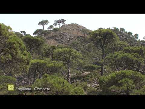
 GR 249 Etapa 6 Pinares de resinero sobre dolomías
 GR 249 Etapa 6 Violeta arbórea
 GR 249 Etapa 6 Curruca rabilarga
 GR 249 Etapa 6 Erésido Loureedia colleni


More information
Discover more about the province of Malaga
- Discover more about the province of Malaga