
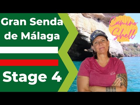
Great Malaga Path (GR 249). Stage 04. Torrox - Nerja
1. Initiation Stage: Torrox Costa.
Access Starting point: Torrox Lighthouse Torrox Costa.
2. Finishing point: Nerja.
Access to finish point: ChÚllar river, Nerja.
Hazards:
Transit along the roadside on some occasions
Road traffic circulating around the beaches of Peþoncillo & Playazo
Wading through the Arroyo ChÚllar waterway
Torrox Point and Peþoncillo (Up`to km 3.5)
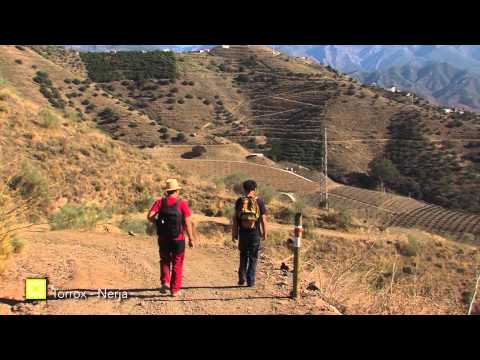
Stage 4 sets off from the emblematic surroundings of the Roman ruins and lighthouse at Torrox, the furthest west of the six in the Province of Malaga. Although it is normally possible to cross the riverbed of the River Torrox directly from the lighthouse pathway, the recommended option is to cross the bridge of the N-340 main road. This is due to the route looping around to the north, passing through gardens and car parks next to the riverbanks, themselves filled with reeds and odd poplar trees.
Once on the other side of the river, you continue a few hundred metres along the cliffs of conglomerate rock, until you find some steps leading down to Peþoncillo beach. A short distance on, on a raised section to your left, there are archaeological remains (km 1.5) with tall buildings just behind. The site around the ancient water-wheel for a well of the Cuartos Catalanes is surprisingly deep, supported by red brick arches and stonework walls.
Returning to the sand, which is fairly firm underfoot, the attractive seafront walkway is not far from the shore but short in length, some 500 metres in total. You then follow a curve inland until you reach the motorway, precisely at the kilometre 285 marker, just next to a sizeable boathouse.
Despite the beach not being very builtup, there are some obstacles that could make walking along the beach difficult. That said, access to the beach from the Great Path is easy and hence frequently done. The route then gains elevation right away, drawing our attention to the cuts into the schist on the far side of the motorway and the first breakwaters formed of enormous boulders between the Great Path and the beach. Soon you reach a pointed boulder on your right-hand side, with some white stairways down to the small beaches and a small, decorated altar in the car park.
The area of sea cliffs (Up to km 7)
A remodeled bend in the road makes it easier to continue along Avenida de Calaceite, soon to arrive at the unusual landscape of the cove of Mazagarrobo (km 3.5). Its grey sand is bordered by craggy cliffs, at the bottom of where we can still find antiquated dry-stone walls. The small sea cliff provides refuge for some autochthonous plants adapted to the sea spray to the right, meanwhile on top of a slightly higher headland is the Calaceite beacon. This displays similar workmanship to other medieval defensive constructions along the coastline. A large sea wall made with limestone blocks sits at the base of the cut made for the road, to prevent any collapse. This provides access by road to the neighbouring residential areas.
Striking mountains tower up on the far side of the N-340, where sparse scrubland is broken up by hundreds of metres of retaining walls made with the same slaty stone. This can be appreciated even more in the immediacy of Vilches beach, at kilometre 5.5. You briefly set foot on the beach, but soon move onto a limited section of the disused main road to begin the ascent, which leads to the highest point on the Stage. This is marked by Macaca Tower at kilometre 6.2, with impressive sea cliffs below, which the path runs close to on several occasions. Entering the built-up area signals your proximity to Nerja, seen to the east and from here you gradually make your way down to sea level.
The beaches and clifftops of Nerja (To the end of the stage)
Continuing on around the edge of highrise buildings with garden areas, until you pass over the difficult-to-spot Arroyo Seco waterway, where you make a sharp turn across a clearing. This takes you Playazo beach, which stretches to almost 2 kilometres long. The scenery here is undoubtedly rather less typical, where a compacted sand track allows cars to access the numerous & ageless agricultural plots. These are elongated in shape and perpendicular to the beach, from where they can be accessed. Many of these plots now tend to be less for horticultural use, instead being fenced off patches with knocked-together huts used to enjoy the beachside location.
There is also an area for motorized watersports and a fishing boat beach mooring. Just further on, you come across the dried river bed of the River ChÚllar, where Stage 4 ends however you can continue along the citys seafront boulevard. Carrying on along the pavement, you reach the ruins that the beach takes its name from, La Torrecilla, built with a combination of masonry and brickwork, it is likely to have originated in the 18th century.
 GR 249. Stage 04. Torrox - Nerja. The landscape of cliffs with agricultural walls and coves at the foot of the path
 GR 249. Stage 04. Torrox - Nerja. The mouth of the Torrox River in summer with the lighthouse in the background
 GR 249. Stage 04. Torrox - Nerja. The Balcony of Europe and behind the Cliffs of Maro and Sierra Almijara
 GR 249. Stage 04. Torrox - Nerja. Slate cliffs cultivated until the 19th century
 GR 249. Stage 04. Torrox - Nerja.
 GR 249. Stage 04. Torrox - Nerja.
 GR 249. Stage 04. Torrox - Nerja.
 GR 249. Stage 04. Torrox - Nerja.
 GR 249. Stage 04. Torrox - Nerja.
 GR 249. Stage 04. Torrox - Nerja.
 GR 249. Stage 04. Torrox - Nerja.
 GR 249. Stage 04. Torrox - Nerja.
 GR 249. Stage 04. Torrox - Nerja.
 GR 249. Stage 04. Torrox - Nerja.
 GR 249. Stage 04. Torrox - Nerja.
 GR 249. Stage 04. Torrox - Nerja.
 GR 249. Stage 04. Torrox - Nerja.
 GR 249. Stage 04. Torrox - Nerja.
 GR 249. Stage 04. Torrox - Nerja.
 GR 249. Stage 04. Torrox - Nerja.
 GR 249. Stage 04. Torrox - Nerja. Entrance to Nerja
 GR 249 Etapa 4 Cortados de esquistos y matorral sobre antiguos cultivos
 GR 249 Etapa 4 Cardo cabrero
 GR 249 Etapa 4 Saltamontes narigudo
 GR 249 Etapa 4 Salamanquesa rosada


More information
Discover more about the province of Malaga
- Discover more about the province of Malaga