
Long-distance Mozarabic Way of St James (GR 245). Stage 03: Villanueva de la Concepciˇn - Antequera
- Access to the Stage:
Municipality of Villanueva de la Concepciˇn, along Calle Loma del Carril, in the north of the town.
- Start of the Stage:
Municipality of Villanueva de la Concepciˇn, along Calle Loma del Carril.
- End of the Stage:
Municipality of Antequera, in calle Jesus.
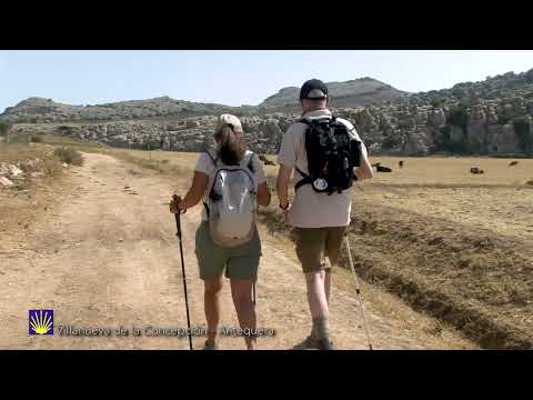
The start of the route is in the north of Villanueva de la Concepciˇn. You will go westwards, along Alhaja and Realenquilla Way, which consists of mild but continuous slopes. Firstly, you will, above all, see olive groves, which are followed by cereals at higher altitudes.
Once you get at kilometric point 4.1, the route turns northwards. After you go over Espinazo Stream, you will continue walking along a track (a way from AlmogÝa to Antequera) at the altitude of Robledillo Farmhouse (kilometric point 6), parallel to the border of Torcal de Antequera Nature Reserve, which was listed as UNESCO World Heritage Site. You will get into a polje, a large, flat depression, which ends close to the karst landscape of Torcal, a famous landmark in this area. We recommend taking some panoramic shots of this unique scenery.
When you get to an altitude of 1,000 metres at the level of Navazos country house (kilometric point 8.2), after a small drop, you will get to Escaleruela mountain pass (kilometric point 9.4), shaped by the Chimenea Mountains with its impressive Peak Camorro Alto (1,378 m) and the Sierra Pelada with the view of one part of Antequera Depression. Go along a narrow winding path which is carved in the rock and that will allow you to descend very fast to a flat area, which goes to the crossroads of A-343 and A-7075 (Torcal Road). Having walked few metres away along the latter oneĺs hard shoulder, you will get into Jesus Steet and reach Antequera. Peregrinos Hostel is at the Church of St James the Great.
 GR 245.3 - Villanueva de la Concepciˇn - Antequera 54
 GR 245.3 - Villanueva de la Concepciˇn - Antequera 53
 GR 245.3 - Villanueva de la Concepciˇn - Antequera 51
 GR 245.3 - Villanueva de la Concepciˇn - Antequera 50
 GR 245.3 - Villanueva de la Concepciˇn - Antequera 48
 GR 245.3 - Villanueva de la Concepciˇn - Antequera 47
 GR 245.3 - Villanueva de la Concepciˇn - Antequera 42
 GR 245.3 - Villanueva de la Concepciˇn - Antequera 49
 GR 245.3 - Villanueva de la Concepciˇn - Antequera 45
 GR 245.3 - Villanueva de la Concepciˇn - Antequera 44
 GR 245.3 - Villanueva de la Concepciˇn - Antequera 46
 GR 245.3 - Villanueva de la Concepciˇn - Antequera 43
 GR 245.3 - Villanueva de la Concepciˇn - Antequera 41
 GR 245.3 - Villanueva de la Concepciˇn - Antequera 40
 GR 245.3 - Villanueva de la Concepciˇn - Antequera 34
 GR 245.3 - Villanueva de la Concepciˇn - Antequera 38
 GR 245.3 - Villanueva de la Concepciˇn - Antequera 36
 GR 245.3 - Villanueva de la Concepciˇn - Antequera 37
 GR 245.3 - Villanueva de la Concepciˇn - Antequera 32
 GR 245.3 - Villanueva de la Concepciˇn - Antequera 33
 GR 245.3 - Villanueva de la Concepciˇn - Antequera 35
 GR 245.3 - Villanueva de la Concepciˇn - Antequera 39
 GR 245.3 - Villanueva de la Concepciˇn - Antequera 31
 GR 245.3 - Villanueva de la Concepciˇn - Antequera 30
 GR 245.3 - Villanueva de la Concepciˇn - Antequera 29
 GR 245.3 - Villanueva de la Concepciˇn - Antequera 28
 GR 245.3 - Villanueva de la Concepciˇn - Antequera 25
 GR 245.3 - Villanueva de la Concepciˇn - Antequera 23
 GR 245.3 - Villanueva de la Concepciˇn - Antequera 27
 GR 245.3 - Villanueva de la Concepciˇn - Antequera 26
 GR 245.3 - Villanueva de la Concepciˇn - Antequera 22
 GR 245.3 - Villanueva de la Concepciˇn - Antequera 21
 GR 245.3 - Villanueva de la Concepciˇn - Antequera 20
 GR 245.3 - Villanueva de la Concepciˇn - Antequera 19
 GR 245.3 - Villanueva de la Concepciˇn - Antequera 16
 GR 245.3 - Villanueva de la Concepciˇn - Antequera 18
 GR 245.3 - Villanueva de la Concepciˇn - Antequera 14
 GR 245.3 - Villanueva de la Concepciˇn - Antequera 17
 GR 245.3 - Villanueva de la Concepciˇn - Antequera 15
 GR 245.3 - Villanueva de la Concepciˇn - Antequera 13
 GR 245.3 - Villanueva de la Concepciˇn - Antequera 12
 GR 245.3 - Villanueva de la Concepciˇn - Antequera 11
 GR 245.3 - Villanueva de la Concepciˇn - Antequera 10
 GR 245.3 - Villanueva de la Concepciˇn - Antequera 9
 GR 245.3 - Villanueva de la Concepciˇn - Antequera 7
 GR 245.3 - Villanueva de la Concepciˇn - Antequera 4
 GR 245.3 - Villanueva de la Concepciˇn - Antequera 2r4
 GR 245.3 - Villanueva de la Concepciˇn - Antequera 5
 GR 245.3 - Villanueva de la Concepciˇn - Antequera 3
 GR 245.3 - Villanueva de la Concepciˇn - Antequera 8
 GR 245.3 - Villanueva de la Concepciˇn - Antequera 6
 GR 245.3 - Villanueva de la Concepciˇn - Antequera 2
 GR 245.3 - Villanueva de la Concepciˇn - Antequera 1
 Foto - GR 245 Etapa 3 Villanueva de la Concepciˇn - Antequera (74)
 Foto - GR 245 Etapa 3 Villanueva de la Concepciˇn - Antequera (63)
 Foto - GR 245 Etapa 3 Villanueva de la Concepciˇn - Antequera (61)
 Foto - GR 245 Etapa 3 Villanueva de la Concepciˇn - Antequera (52)
 Foto - GR 245 Etapa 3 Villanueva de la Concepciˇn - Antequera (48)
 Foto - GR 245 Etapa 3 Villanueva de la Concepciˇn - Antequera (47)
 Foto - GR 245 Etapa 3 Villanueva de la Concepciˇn - Antequera (45)
 Foto - GR 245 Etapa 3 Villanueva de la Concepciˇn - Antequera (40)
 Foto - GR 245 Etapa 3 Villanueva de la Concepciˇn - Antequera (31)
 Foto - GR 245 Etapa 3 Villanueva de la Concepciˇn - Antequera (39)
 Foto - GR 245 Etapa 3 Villanueva de la Concepciˇn - Antequera (38)
 Foto - GR 245 Etapa 3 Villanueva de la Concepciˇn - Antequera (25)
 Foto - GR 245 Etapa 3 Villanueva de la Concepciˇn - Antequera (8)
 Foto - GR 245 Etapa 3 Villanueva de la Concepciˇn - Antequera (6)
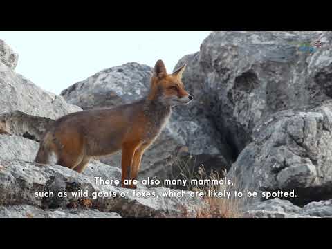
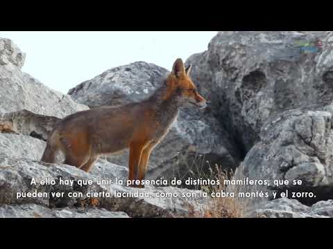
 GR 245 Etapa 3 Cabra montÚs (Capra pyrenaica)
 GR 245 Etapa 3 Pastizal en la falda del Camorro Alto
 GR 245 Etapa 3 Espejo de falla
 GR 245 Etapa 3 Espino majoleto (Crataegus monogyna)


More information
Discover more about the province of Malaga
- Discover more about the province of Malaga