General Information - Cultural Significance of the Site: High - Scenic Value of the Site: High - State of Conservation: Medium - Kind of Works: Farmstead where raisins are made. - Stages of the...
This web page uses its own cookies and the third-party cookies to collect the information which help us make the service as good as possible. By no means is our intention to use it for gathering personal data.

Comares is a Moorish village located on the border between the region of AxarquĒa and the Montes de Mßlaga. It is known as the "Balcony of the AxarquĒa" because of its privileged position on a mountain top.
Its labyrinth-like streets and its architecture, a reflection of its Moorish roots, are the most characteristic features of its urban landscape. The Ruta de la Pasa (Route of the Raisin) should not be missed. This village is also the birthplace of verdiales, a particular style of folk song in the villages of Malaga and which carries the name of the village.
The Comares Castle and the Aljibe de Mazm·llar form part of the rich heritage left by the Arabs in this village of AxarquĒa. The fortress still preserves two of its turrets and part of the ancient wall, which is known as La Tahona. The well, built during the 13th century, was declared a national Historical-Artistic Monument.
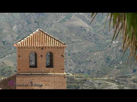
The Iglesia de Nuestra Se±ora de la Encarnaci¾n is another one of the main architectural features of Comares. This Mudejar-style church is located at the highest part of the village. It was built during the 16th century, although the Sagrario chapel was added at a later date. It has three naves and its distinctive features include its Mozarabic tower.
 Plaza Balc¾n de la AxarquĒa, s/n, 29195
General Information - Cultural Significance of the Site: High - Scenic Value of the Site: High - State of Conservation: Medium - Kind of Works: Farmstead where raisins are made. - Stages of the...

The remains of a wall of the castle of Comares, whose exact date is unknown, and which was transformed into a huge fortress during the Moorish occupation. It was built on what is today Camposanto...

General Information - Cultural Significance of the Site: High - Scenic Value of the Site: High - State of Conservation: Medium - Kind of Works: Farmstead where raisins are produced. - Stage of the...

This climbing trail consists of a couple of not very complicated slopes, so it can be defined as a K2 route. There is a zip-line for speed pulleys. If you have usual ones, you will need to sway. It...

This via ferrata is rather amusing as it has four bridges and only one overhangs which is not very difficult to climb. The trail extends lengthways, which makes it manageable. It can also be...

Its name comes from the Arabic ōhisn qumarichö meaning castle up the hill. Name of its inhabitants: Comarenos. Legend: There are two legends or stories that deal with the link between...

This festival has been declared to be of Tourist Interest by the Provincial Council of Mßlaga. Please check with the local Town Hall or Municipal Tourism Office for the festival date before...

The origins of Comares as a village are somewhat confusing and, although nobody questions its importance during the Arabic occupation, there are no clear indications that they were the founders of...

UNIQUENESS El Molino de Abuelos goes back to the year 1800, when it was used as an olive-oil mill. The house has a patio and wonderful views. It was restored and transformed into a country house...

Through its website, the municipality offers information on the most relevant activities that take place regularly. If in doubt, contact the Town Hall.

The AxarquĒa Vantage Point is close to the Town Hall, and offers magnificent views of this area.ĀThis is one of the highest viewpoints throughout the AxarquĒa , from where you can see 11 villages ,...

The Plaza de los Verdiales gets its name for being dedicated to this folkloric expression, since in Comares they are very important. In it we find plates, images and a statue, dedicated to this...