
Great Malaga Path (GR 249). Stage 15. Villanueva de Algaidas - Cuevas Bajas
1. Initiation Stage:
Access Starting point: There areĀtwo connections, Seville-Granada A-92,ĀA-7201 from Archidona and the A-7221Āfrom Antequera.
Starting point: At the crossroads ofĀMA-6416 with the MA-7203 to CuevasĀBajas, at the northern end of the mainĀcentre of population of the village.
Enjoy the walk safely:Ā You have to stock up on water in the heat,Āsince there is no drinking water along the walk.ĀBe careful with the traffi c on the road beforeĀreaching Cuevas Bajas.ĀThe paved track before that does not holdĀdanger as there is scarce transit of vehicles.Ā
2. Completion of Stage:
Access to finish point:Ā From VillanuevaĀde Algaidas the MA-7203.
Finish point: Arroyo of Barranco Hondo,Āafter crossing the village of Cuevas Bajas,Āat the south-western tip of the village.
3. Alternatives:
Possible "escapeĀ routes": They areĀnot necessary to plan at this stage, givenĀits short length and low difficulty.
No return point: Once you are on top ofĀCerro de la Cruz it is worth it to continueĀgoing down instead of coming back. TheĀsettlement El Cedr¾n is already quite close.
Connections to other footpaths and trails:Ā
GR-7 E-4, Tarifa to Athens, Northern route ¢ Almost total overlap, GR-7 E-4, Tarifa to Athens - Links up in Cuevas Bajas (Variant), GR 249.3, Variant 3 of the Great Malaga Path, GR 245, Mozarabic Way of the Camino de Santiago ¢ Total overlap.
Hazards:
Ģ Road traffic circulating along the country tracks
Ģ Road traffic in El Cedr¾n and on the A-7300 road
The River Burriana and the Great Path (Up to km 2)
Villanueva de Algaidas is actually made up of numerous semi-urban areas: El AlbaicĒn, La Parrilla, Zamarra, Solana, Barranco del Agua, La Atalaya and Rincona. The main hamletÆs location in a ravine is mainly down to the geography. It was easier to defend, is next to the watercourse and has sandstone building material nearby. This is the setting for the first two kilometres of the stage.
At the crossroads to the north of the village, you take a path going down towards La Atalaya. The path fords a small stream that has carved a channel into the sandstone and heads towards the ruins of the old convent. Similarly, the transit of countless horses and people has carved a deep pathway in the limestone rock, even with the horseshoe marks still visible after so many years.
Coming up on your left are the convent and the Mozarabic chapel, which is set into the rock and faces west. Meanwhile, the path descends to the right towards the river gorge. At the exit of the shaded gully is the Convent of Our Lady of the Consolation of the Woodland, which was built in 1566. Attached to the ruins of the convent is a Mozarabic cave chapel dating back to the around the 9th or 10th century, and can normally be visited easily.
The vegetation becomes thicker and more diverse in this section, which is protected by railings that allow you to get close to the sandstone cliffs. The River Burriana is called as such from Villanueva de Algaidas onwards and the pathway uses the Puente Viejo (Old Bridge) to cross it. This is a handsome structure with a main central arch and two lateral arches to allow for flood water.
The next section leads on to La Atalaya and there is an interesting lookout point over the route already covered. By the side of the path, you can see the hollows carved out of the rock when the water level of the river was higher. The rock retains its attractive earthy yellow colour in these cavities, but turns a black ash colour in the cuts exposed to rainwaterÆs oxidising action. There is luscious vegetation in the gully, with large Hackberry bushes and Elm trees standing out most.
La Loma de la Cruz and the farmhouses of Cuevas Bajas (To the end of the stage)
As soon as you leave La Atalaya after a little meandering through its streets, you take a track off to the right and climb a steep slope, heading north along the Camino de las Algaidas track. Turn around occasionally to take in the panoramic views over the village and the Sierra de Arcas hills beyond, with its wind farm along the top. You pass by some ruins halfway up the slope, with numerous rabbit burrows nearby. When the slope begins to level out a little, you soon reach the summit, at kilometre 4. You then come to the country estates of Cortijos de la Loma Vieja, cross its threshing floor and then pass by the nearby Cortijo de la Loma Nueva, both with palm trees on their doors. The exact point where the three municipalities meet is close to the road, however the route continues on, passing a small reservoir on a small hill to the left, where the path begins to go down.
On the way down, keep an eye out for the Chaparro Bolondro, an impressive oak tree on the right, next to some houses. It is the largest in the area and so adored locally that it has its own information board further down at El Cedr¾n estate. This is not far on, but first there is the must-see of the lookout spot of El Cedr¾n at kilometre 6.2. It offers a quite exceptional and unrivalled view of the countryside of the provinces of C¾rdoba and Granada. There is a panoramic information board that explains the view well. As they say in the nearby Cuevas Bajas, this is the spot where æMalaga overlooks the Genil valleyÆ.
During the descent, the pathway begins to turn west before reaching the country estate of El Cedr¾n, with its communal oven and its rich history. A dozen white houses line the main street with its cobblestones still visible, and along which the path goes. At the exit, there is a turn-off to La Moheda, which is also the route selected by the Mozarabic Way. The southern branch of the GR 7 takes a different route, to pass through Las Molinas.
The route enters the village from the southeast along Calle Archidona. You pass the main square with the church of San Juan Bautista with its exposed brick fańade, the baroque clock tower and the belfry with three bells. The stage ends next to the River Burriana, almost at the point where it meets the Genil. It is on an avenue that is well signposted for hiking and other outdoor activities, including canoeing and rafting.
 GR 249. Stage 15. Villanueva de Algaidas - Cuevas Bajas. The Franciscan convent with the path surrounding it to the east
 GR 249. Stage 15. Villanueva de Algaidas - Cuevas Bajas. Mozarabic rock church and Villanueva de Algaidas La Atalaya, seen during the first steps of the day
 GR 249. Stage 15. Villanueva de Algaidas - Cuevas Bajas. Majestic ruins of the Franciscan convent of our Lady of the Consolation of the Algaidas
 GR 249. Stage 15. Villanueva de Algaidas - Cuevas Bajas. Medieval bridge and the Bebedero stream
 GR 249. Stage 15. Villanueva de Algaidas - Cuevas Bajas. The farmhouse of La Loma, a traditional farmhouse, in ruins
 GR 249. Stage 15. Villanueva de Algaidas - Cuevas Bajas. One of the beautiful corners of the farmhouse of El Cedr¾n
 GR 249. Stage 15. Villanueva de Algaidas - Cuevas Bajas. The Burriana River Gorge, excavated in the sandstone rock
 GR 249. Stage 15. Villanueva de Algaidas - Cuevas Bajas.
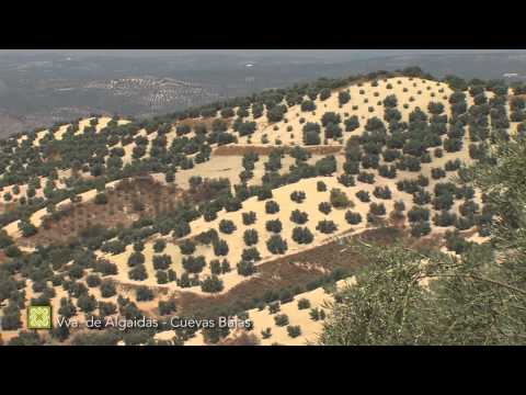
 GR 249. Stage 15. Villanueva de Algaidas - Cuevas Bajas. Villanueva de Algaidas from GR-249 climbing Cerro de las Cruces
 GR 249. Stage 15. Villanueva de Algaidas - Cuevas Bajas. The River Burriana in Cuevas Bajas, very close to its mouth in the Genil
 GR 249. Stage 15. Villanueva de Algaidas - Cuevas Bajas. A great place from which to see the Valley of the Guadalquivir, the viewpoint of the Cedr¾n
 GR 249. Stage 15. Villanueva de Algaidas - Cuevas Bajas. Panoramic view of the Genil valley
 GR 249. Etapa 15. Villanueva de Algaidas - Cuevas Bajas. Iglesia Rupestre Mozßrabe entre Villanueva de Algaidas y La Atalaya, en los primeros compases del dĒa
 GR 249 Etapa 15 Garganta del rĒo Burriana
 GR 249 Etapa 15 Almez (Celtis australis)
 GR 249 Etapa 15 Pßjaro mosc¾n europeo (Remiz pendulinus)
 GR 249 Etapa 15 Libķlula africana (Crocothemis erythraea)
 GR 249 Etapa 15 Culebra bastarda (Malpolon monspessulanus)


More information
Discover more about the province of Malaga
- Discover more about the province of Malaga