
Great Malaga Path (GR 249). Stage 24. Ronda - Estación de Benaoján
1. Initiation Stage:
Access Starting point: Ronda can be reached from Málaga on A-367, from Costa del Sol on the A-366, on the A-374 from Sevilla and from Algeciras on the A-369. Yu reach the old town in Ronda on the Calle Armińán, which connects Puente Nuevo with the Barrio de San Francisco. In order to reach Plaza del Campillo you must follow the streets direction west.
Starting point: Plaza de María Auxiliadora or del Campillo, in the old part of Ronda known as La Ciudad, very close to Puente Nuevo.
Enjoy the walk safely: From km 4.6 walk about 300 metres along the road connecting Benaoján and Ronda, the MA-7401, passing by the houses of La Indiana on either side. There is no hard shoulder in some sections. A little further you must cross the train line Algeciras-Bobadilla on an unprotected level crossing without automated barriers. This section of train tracks is straight and well visible but you must take extreme precautions in case of fog or rain and get information on the times of passing trains beforehand. Between Benaoján and la Estación there is a comfortable paved path but access to it, as you leave the village on the road, is still pending improvement (year 2014), the road has no hard shoulder and there are a few bends; this means walking must be done with extreme care. It wouldn´t be a bad idea to make yourselves highly visible with refl ective clothing and lights.
2. Completion of Stage:
Access to finish point: Access road to Estación de Benaoján from MA-7401.
Finish point: Estación de Benaoján, in the square close to the train station.
3. Alternatives:
Possible "escape routes": Up to kilometre 4.5 you can reach the MA-7401 at the level of the La Indiana settlement, but actually the road is very close to the left of the walk, from km 3. On the other hand Benaoján is a very good place to stop walking, even though it is very close to the finish.
No return point: From la Pasada de Gibraltar onwards it is best to continue to Benaoján.
Connections to other footpaths and trails:
GR 141, Great Path of the Ronda Hills, overlap, SL-A 38, Loop of La Caldera – El Tajo mills, partial overlap, PR-A 251, Ronda-Montejaque y PR-A 253 , Ronda-Benaoján, partial overlap, GR-7 E-4, Tarifa to Athens, partial overlap, SL-A 138, River Guadiaro & SL-A 139, El Gato cave, link up at end.
Hazards:
• Road traffic circulating on tarmacked surfaces
• Railway level crossing with no barriers.
The basin of La Hoya del Tajo (Up to km 3)
The route leaves Ronda by going down the well-known Camino del Campillo way. At a sharp bend and surrounded by Almond trees, the paved pathway passes by the access to the base of the Puente Nuevo bridge on your right.The two via ferrata climbing routes in the gorge also finish here. At the next turn- off not far on, you reach the rammed-earth wall of the Albacara or Fortress. Keeping the access to the Cristo or Los Molinos gate on your right, the route heads off to the left, towards the gate of El Viento.
Roughly 500 metres on, you join the Camino de los Molinos track. This wide & cobbled road was built for the construction of the Ronda hydroelectric power station in the1940s,preciselywhereitleads.Thereis a level section at the start of La Cuesta del Cachondeo (Joke Hill), which has one of the best views of the Puente Nuevo and the walls of the Tajo.
You then come to the entrance of a hostel and soon after, to two restored mills. Once you have passed the cobbled road turn-off to the right that leads to the power station, the irrigation channels of the River Guadalevín give way to plots of farmland and orchards. There is then a steep descent down a concrete track. This brings you onto the flood plains of the Guadalevín river, which flows from the Sierra de las Nieves.
An uphill section takes you past more plots of farmland and Walnut groves to an interesting property that has preserved its unrendered medieval tower. You then continue past vineyards, country houses and an equestrian centre until you reach one of the natural exits of La Hoya basin, by the saddle of El Puerto de la Muela. The best views of the first 3 kilometres are from here.
El Mercadillo typical ‘Dehesa’ land & La Indiana (Up to km 5)
The gravel track then comes to an important cross roads, which links the two footpaths that come down from Ronda through the semi-urban park named Dehesa del Mercadillo. This wooded area of Stone pines with a few Holm oaks amounts to some 138 hectares.
The path then heads mainly west, leaving the Pine forest and soon comes to some old quarries and abandoned rubbish dumps. It then passes nearby the area’s solid waste transfer site, which is on the right at a bend in the road. You now come on to the ‘Cańada Real’, an ancient livestock track of the region of Campo de Gibraltar, which goes down towards La Indiana through farm land and past the chimney of an old olive press. Just before reaching the road, the old Parochial School is on your left. A small group of houses line the road in this hamlet of Hoyo Tabares. You then leave the road at kilometre 5 to go down to the banks of the Guadalevín once again.
The River Guadiaro and the Old Road (Up to km 10)
Downstream from the confluence of the Guadalevín and Guadalcobacín rivers, it be- comes the Guadiaro River and the route turns south-west to follow it. After the ruins of a house on the Arroyo del Cupil stream, we reach the barrier-free level crossing of the Algeciras - Bobadilla railway line. Once over the other side, the GR-7 E-4 breaks off and makes its way towards Montejaque, while you continue parallel to the railway track, now within the Sierra de Grazalema Natural Park.
There is a tall Ash tree near a spring that signals kilometre 7, almost as if it were a milestone.Rightonthe8-kilometremark, you leave the track and start along a footpath, near the Gibraltar Ford.
The first significant uphill climb is not far on, through the foothills of the Sierra del Algarrobo mountains, known as Los Pajarejos. A dense layer of White broom covers the landscape, along with Dwarf fan palms, Wild Olive trees and a few Holm oaks. Further on down, the river clings to the rockface, having flowed out of the Cueva del Gato cave system, which can be seen just below the path up ahead. You pass by an unauthorised access to the cave that drops down to the left. The pathway has cobblestones in the steeper areas, and is reinforced by dry stone wall terracing. On reaching the Ronda pass, which is surrounded by Olive groves, you have already covered 10 kilometres.
Benaoján, between river and mountains (To the end of the stage)
The way down to the plains of La Vega de Benaoján is on a wide concrete track with occasional exposed areas of the old cobbles- tones. Just on the left-hand side of the path, on a bend is the protective cover of a small sima or natural sinkhole. Continuing on, you pass the old Benaoján rubbish dump below you before arriving at the La Vega, (the valley floor) and its meandering stream of the same name. Going past farmland, warehouses and the cemetery, it is mainly tarmacked tracks as you cross the village from north to south, between kilometres 11 and 12 of the route.
The long avenue continues downhill after the Plaza de la Constitución. La Estación (the train station) of Benaoján can be reached by following the pedestrian walkway next to the Ronda road, passing the climbing walls and the via ferrata on your left. Above the source of the Cascajales stream, you can also see the end of the children’s via ferrata, which starts at the river. The pavement ends at a viewpoint where there is a drinking water point, with excellent views of the hamlet of Benaoján station.
The pathway, known as the trocha, passes a small house and the pipelines of La Serranía hydroelectric power station on your left. From the houses, cross the level crossing and turn left. Via an irrigation channel you reach the pools of El Charco de la Barranca, where you cross the River Guadiaro over the stepping stones of the weir and turn right to reach the end of the Stage.
 GR 249. Stage 24. Ronda - Estación de Benaoján. The Tagus and the Hoya from the beginning of the Trail in Ronda
 GR 249. Stage 24. Ronda - Estación de Benaoján. The Guadiaro River in El Charco de la Barranca
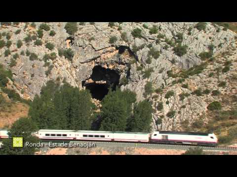
 GR 249. Stage 24. Ronda - Estación de Benaoján. The Cat Cave (Cueva del Gato) and the Gaduares River
 GR 249. Stage 24. Ronda - Estación de Benaoján. Start trail in Tajo de Ronda
 GR 249. Stage 24. Ronda - Estación de Benaoján. Ronda Depression, mosaic of crops, network of roads and Guadalevín riverbed
 GR 249. Stage 24. Ronda - Estación de Benaoján. Initial section that runs through pine forest area
 GR 249. Stage 24. Ronda - Estación de Benaoján. Confluence of the Guadalcobacin and Guadalevin rivers
 GR 249. Stage 24. Ronda - Estación de Benaoján. Small stretch that runs along the road
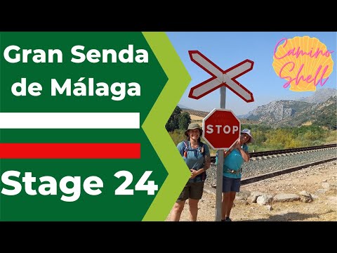
 GR 249. Stage 24. Ronda - Estación de Benaoján. Train level crossing
 GR 249. Stage 24. Ronda - Estación de Benaoján. Incorporation into Cańada del Campo de Gibraltar
 GR 249. Stage 24. Ronda - Estación de Benaoján. Section by lane parallel to the train
 GR 249. Stage 24. Ronda - Estación de Benaoján. The Cat Cave (Cueva del Gato)
 GR 249. Stage 24. Ronda - Estación de Benaoján. Views at the end of the trail
 GR 249. Stage 24. Ronda - Estación de Benaoján. Access bridge to Benaojan Station
 GR 249. Stage 26. Jimera de Líbar - Benalauría. La Laguna Florida takes its name after the crowsfoot flowers appearing in spring
 GR 249. Stage 24. Ronda - Estación de Benaoján. La Cueva del Gato during one of the high water seasons
 GR 249. Stage 26. Jimera de Líbar - Benalauría. A group of walkers enjoying la Laguna Honda or Florida, with Sierra de Líbar in the background
 GR 249. Stage 24. Ronda - Estación de Benaoján. A group of climbers against the grey limestone with Benaoján in the background and the promenade used by the Great Path below
 GR 249. Stage 24. Ronda - Estación de Benaoján
 GR 249. Stage 24. Ronda - Estación de Benaoján. Puerta del Viento and Albacara walls
 GR 249. Stage 24. Ronda - Estación de Benaoján. Puente de Fortuna at the Pasada de Gibraltar, which you do not cross
 GR 249. Stage 24. Ronda - Estación de Benaoján. A few via ferrata climbers with the picturesque Puente Nuevo in the background
 GR 249. Stage 24. Ronda - Estación de Benaoján. Rock-dwelling vegetation in travertine rock of Tajo de Ronda
 GR 249. Stage 24. Ronda - Estación de Benaoján. The balconies of la Alameda del Tajo and a rocky escarpment
 GR 249. Stage 24. Ronda - Estación de Benaoján. The characteristic shape of the Asa de la Caldera (pot handle)


More information
Discover more about the province of Malaga
- Discover more about the province of Malaga