
Great Malaga Path (GR 249). Stage 30. Estepona - Marbella
1. Initiation Stage :
Access Starting point: The Mediterráneo motorway A-7 and the AP-7 Autopista de Peaje (toll motorway). The long coastal Avenida de Litoral that leads to Estepona follows the route of the old N 340, which is the eastern access to the city, and this is the road that leads to the starting point.
Starting point: seafront promenade in Estepona, at the east end of the beach of la Cala, just above the little wooden bridge built over the Arroyo de la Cala.
Enjoy the walk safely: In the fi rst section, just as you start walking along the beach, the path leads along a clay cliff. There is a potentially problematic point at the end of the cliff as water can rise right up to its edge during high tide.
It´s worth looking up the tide time-table and in case of the sea rising, take the paved path just above the escarpment instead. Also, the compacted clay terrain can be very slippery when wet, take care not to slip and fall. There are other sections where the stretch of sand you´re walking on is reduced to the minimum and becomes very narrow but this should not cause any serious problems. Another issue is your having to cross various rivers, especially the Guadalmansa and the Guadalmina. As there aren´t any pedestrian bridges, you must look for a road bridge in case the water levels are high, and these bridges are quite far from the coast.
As far as the rest of the rivers are concerned, and you cross them fi rst, fording them is less complicated and there are road bridges close by. Be careful with the sun, you will be walking either into the sun or having it right behind you, considering the direction of the path. It is highly recommended that you use sun block cream and wear a hat.
2. Completion of Stage:
Access to finish point: The A-7 and AP-7. The main Avenida of Marbella is the perfect link; use as a reference the roundabout Boulevar Príncipe Alfonso de Hohenlohe.
Finish point: At the promenade (Paseo Marítimo) of Marbella and the mouth of the Arroyo Guadalpin, close to the Palacio de Congresos in the centre of the city.
3. Alternatives :
Possible "escape routes": The Autovía del Mediterráneo or the old N-340 are always located towards the interior, to the north, and not too far away. There are numerous streets that lead to these two main roads which have bus lines running in both directions.
No return point: the Guadalmina can be taken as the halfway point of the route, and therefore from there on it´s best to continue ahead.
Connections to other footpaths and trails:
GR-92 E-7, Coastal Path, overlapping throughout.
Hazards:
• Road traffic circulating on few occasions
• Activities involving light vehicles and a kite-surfing area
• Wading through some watercourses.
Coastal cliffs and pebble beaches (Up to km 3)
The stream of the Arroyo de la Cala and its beach are the starting point, and whose seafront boulevard you walk along for about 500 metres. This brings you to the wooden walkways over the large clay bank that constricts the tiny pebble beach. Lush vegetation covers this area while garden plants also thrive.
When you turn the corner at Los Mármoles Point, there is a stretch of sand and pavement that leads away from the small beach of La Plata. You cross a bridge over the Hornacinos stream near a restored waterwheel, with a nearby aqueduct to supply water. The beach at La Plata Point is not of the highest quality due to its size and pebbles, but it is an excellent place to see seabirds and shorebirds, thanks to the relative peace and quiet.
One can deduce the existence of a waste water pipe here, mainly for the open trench cut into the hardened clay filled with rocks and sand. It forms a channel between the raised white manholes, standing a metre above the ground. The route then runs alongside a private estate with a wide stretch of woodland that reaches up to the main road. Different materials are used for the pathway covering this next section, connected to the adjacent properties and their gardens.
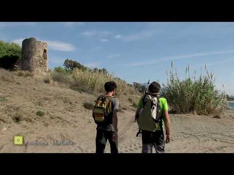
The mouths of the rivers from Sierra Bermeja and the watchtowers (Up to km 7.8)
After 3 kilometres from the start, you reach an area of much larger beaches as a result of, among other things, the numerous rivers that flow into them, each with a modern bridge. The first is El Padr n (or Pared n), characterised by its beds of reeds and canes. As a fine example of the evolution of the coast and its contrasts, the first medieval watchtower sits in the gardens of a luxury hotel. Meanwhile, there is a small vegetable patch on the beachfront, sheltered from the sea breeze by fences of reeds and native vegetation. Also protected here are the areas of Sea wallflower (also known as Sand stock), one of the most colourful coastal plant species.
El Castor River is very similar in appearance to the previous watercourse. It lends its name to the next Point and has the longest section of boardwalk. After you cross this, the Veler n tower comes into view on a rise (adapted for easier access). Despite not being as well preserved as the previous tower, it is of the same period, the start of the 16th century.
Then you come to a second boat yard with some traditional fishing boats and the winches used to drag them up the beach, away from the waves. On the beach, is an interesting bank formed of clay, that is home to some interesting plants and has a hardened upper crust. Nearby and next to a pumping station, a housing development is under construction. Then on the left, it varies between undeveloped fields or abandoned houses and, more frequently, landscaped housing developments, whose paths you continue along.
When you cross the Las Ca as stream (km 6.5) along its long, curving walkway, you come to a residential development with a large landscaped garden. The Guadalmansa (or Desmochada) tower is located here, with archaeological excavations at its base and one of the main landmark of the day. You then come to El Guadalmansa Point.
The beach & dunes at El Saladillo (Up to km 13.7)
The mouth of the Guadalmansa, which is the first reasonably-sized river on the Stage, is not far on. The wide pool has formed here and is several hundred metres long, lined by riverside vegetation on both sides and has some interesting fauna. The area is also used for water sports. A little further upstream is the main pumping station for the treatment of wastewater.
After 9 kilometres from the start, you arrive at the first area of sand dunes on the Costa del Sol, with traces of the vegetation that was once prevalent at the Saladillo point. The long list of species linked to these sandy environments along this entire stretch, are admirable. Some of these even reach just short of the shoreline. On the whole, there is at least one species in flower at any given moment, even in the height of summer. There are spectacular examples here, such as the Madonna lily or European sea rocket.
The Taraje stream is the next watercourse and leads on to the Saladillo tower (km 10.1). It is similar to those seen earlier, but located on a tarmac roundabout. At the Saladillo stream there is a wastewater pumping station and a little further on, another at the mouth of the Dos Hermanas stream, which displays some reasonably sized Poplar trees.
A little further on, after some Stone pines that are moulded by the wind, there is another dune system, called Matas Verdes (or Casasola). It is separated from the last of Estepona’s coastal forests by a wooden fence that prevents access to a Pine forest with Cork oaks. In the clearings there is dense brush of Mastic trees, Dwarf fan palms, Phoenician junipers, African sandalwood, Spiny broom and Black hawthorn. A sign indicates that a second population of Posidonia is found on the seabed here, protected as a Site of Community Importance (SCI).
The Bańos (or Casasola) Tower is the next landmark you come across. A fence stops you from entering, but it is the smallest in diameter along this part of coastline. It is the only one that is horseshoe-shaped, since its northern face is completely flat. This watchtower gives way to a narrow section at Bańos Point and then to cross the river Guadalmina, where you enter the municipal area of Marbella, after a new pumping station at kilometre 13.7.
The Seafront Boulevards of San Pedro and Marbella (To the end of the stage)
The green grass of the golf course beside the river quite literally touches the sand and at the end of a large beach is Las B vedas Tower. Exceptionally well preserved, this is found in a first class and very well cared for archaeological site, sharing the site with the Roman baths of Las B vedas. This is not the only surprise around the mouth of the Chopo stream (km 17). There is a collection of traditional boats and winches, which are located on a mound and point to a kind of fishing village under some Eucalyptus trees. The early Christian church of Vega del Mar is to be found here.
You cross the river Guadaiza while on San Pedro de Alcántara’s seafront boulevard, followed on by that of Marbella until the end of the Stage. One of the aspects that makes this long stretch more captivating, is the variety of the path’s design. The surfacing can be paved or cobbled, made of natural stone, Albero sand or wood. At different moments, you will encounter a safety barrier on the right, railings with various designs, jetties and breakwaters of boulders. Throughout this section, however, landscaped gardens are common and show a similar variety of styles. Although the housing developments and private properties are all set a varying distance back from the beach, in general they leave a fairly wide strip of land for the path or for relaxing on any one of the beaches.
Continuing on, the breakwaters and beaches of Nueva Andalucía lead on to El Duque Point, with its famous marina of Puerto Banús (km 19.8). Just before this however, the quadrangular tower of El Duque, of Muslim origin can be seen in a private garden. The Verde River is fairly wide at its mouth and has a large and deep expanse of water. Waterfowl, both wild and domesticated are easy to spot here and are very accustomed to the non-stop movement of passers-by walking or exercising. As soon as you cross the river, look between the houses on the left bank for a plot of land not too far from the beach. This is the very important site of the Roman villa of Río Verde.
The last watchtower of the day is a little difficult to locate, being higher above the beach than the others, at Nabules Point. Found at kilometre 22.3, the Ancón tower is a similar size and structure. The large rise that the Tower sits upon is due to the fact that, among other things, the coast is very rocky here but still very flat for the first time in the stage. In effect, this tower has a much better base compared to others, which are more affected by erosion.
The end of the Stage gets ever closer as you continue along a long stretch of promenade of Albero sand and past an outdoor gym equipment. Cross the Nagüeles stream and you go past a beautiful Pine forest on the left at Casablanca beach and the route finishes at the mouth of the Guadalpín stream in the centre of Marbella.
 GR 249. Etapa 30. Estepona - Marbella. The footbridges of Estepona saving the first clay cliff
 GR 249. Etapa 30. Estepona - Marbella. The predominant watchtowers were built in the 16th century
 GR 249. Stage 30. Estepona - Marbella. Mouth of the Verde River with water in the middle of summer
 GR 249. Stage 30. Estepona - Marbella. Trawling lathes and port of call of traditional fishing boats
 GR 249. Etapa 30. Estepona - Marbella. The new lighthouse of San Pedro a few meters from the old
 GR 249. Stage 30. Estepona - Marbella. Wide beaches at the end of the Trail in Marbella
 GR 249. Stage 30. Estepona - Marbella. Coast of Estepona
 GR 249. Etapa 30. Estepona - Marbella. Ruddy Turnstone
 GR 249. Etapa 30. Estepona - Marbella. Great Cormorant
 GR 249. Etapa 30. Estepona - Marbella. Velerin Tower
 GR 249. Etapa 30. Estepona - Marbella. Guadalmansa Tower
 GR 249. Etapa 30. Estepona - Marbella. Boats
 GR 249. Etapa 30. Estepona - Marbella. Coastal and peak of the Shell (Concha)
 GR 249. Etapa 30. Estepona - Marbella. The Vaults (Las Bóvedas)
 GR 249. Stage 30. Estepona - Marbella. The coastal sands harbour such plants as Lotus creticus
 GR 249. Stage 30. Estepona - Marbella. Wading birds feeding at the beach
 GR 249. Stage 30. Estepona - Marbella. Housing estate reaching down to the beach
 GR 249. Etapa 30. Estepona - Marbella. Pebbles of very diverse origins and composition
 GR 249. Stage 30. Estepona - Marbella. Ants feeding in the flowers of European Searocket
 GR 249. Stage 30. Estepona - Marbella. Mouth of the río Velerín
 GR 249. Stage 30. Estepona - Marbella. Río Guadalmansa river mouth and Sierra Bermeja in the background
 GR 249. Stage 30. Estepona - Marbella. Dunes and pine wood of Saladillo
 GR 249. Stage 30. Estepona - Marbella. Roman baths of Las Bóvedas
 GR 249. Stage 30. Estepona - Marbella. Winches and traditional boats along the string of dunes


More information
Discover more about the province of Malaga
- Discover more about the province of Malaga